Days: 1   | 2   | 3   | 4   | 5   | 6   | 7   | 8a   | 8b   | 9   | 10   | 11   | 12   | 13   | 14   | 15   | 16   | 17   | 18   | 19   | 20   | 21   | 22 & 23   | 24

Wednesday, June 30, 2010

On Top of the World (Day 17)

Today we headed east of Chicken AK onto a section of road called "Top of the World Highway."  We were already on the dirt section of road, and it continued on until the border crossing.

It rained a bit last night making the road a bit snotty, but nothing compared to the Dalton Hwy.  We were able to travel 25 to 50 mph.  There was a point I thought our luck ran out when heavy fog set in causing the views to disapear, but it turned out the road was just taking us in and out of the cloud base.

It was a little slow at times, but we finally got to the Yukon River, where we took a free ferry across to Dawson City.  Dawson is a time warp to the gold rush days.  The place has a very authentic old time feel to it, dirt roads and all.  Everything is pretty expensive here too.

We're going to stay somewhere around here and explore the town a little more tonight. Then we're heading to Whitehorse tomorrow to meet up with Steve tomorrow.

Note that if you are trying to contact me, my mobile phone will be off until we get back to the states.

Tuesday, June 29, 2010

Alaskan Chicken (Day 16)

Paul and I packed up and had some breakfast at the Hillside truckstop, about 60 miles south of the Dalton Highway near where we camped.

We ran across a rider, Vin, the night before at this truckstop while topping off the tank.  Vin is going to ride the Dalton Highway on a Sym Symba.  It's a moped that has a one gallon tank and gets 100 mpg.  He has two other one gallon containers with him as well as a couple spare tires.  The tread pattern on the tires are at least decent for dirt.  Since the forecast was calling for rain over the next couple days, he said he would only attempt to go as far as the Arctic Circle.  Good Luck!

First thing on the agenda was to wash all the mud off my bike. Once that was done, we were headed for Dawson City, Yukon Territory but planned to camp somewhere along the way.

It was raining when we were leaving the car wash so we put on the rain gear.  We've been warned of a 75 mile stretch of road that could get ugly if it is wet, but after the Dalton experience, we figured we would just figure out what to do when we got there.

Luckily, we rode past the rain and on to sunny skies with big puffy clouds. It wasn't a long ride because of all the errands in the morning and the marathon ride yesterday.

Chicken Alaska is a lot more intersting than I thought it was going to be.  The first thing I saw was a "Chicken Community" sign, and I wasn't sure if there was going to be much else, so I got a picture.  Then, we rode up on the Chicken Post Office, again a picture not knowing if there was going to be anything else.

Then around the corner was a bunch of old fashion buildings... with 2 tour busses and a lot of people all over the place standing in the middle of the road like sheep that had no clue I was trying to get through them to park.

Turns out these people had reason to be in a daze.  Their first tour bus went off the road in Eagle AK.  They got transferred to another bus, which was the one out front here, and it was stuck in a hole.  They finally teathered one bus to the other, and the front tour bus, filled with its passengers, towed the other bus out of the hole.  The crowed was pleased and the town emptied quickly.  This must have been a big day for Chicken.

In the little town there's a lot of mining equipment on display, a small row of shops (saloon, restaurant, gift store), an RV/camping park with a big general store with lots of Chicken AK apparel, and a do it yourself gold panning area.

Once we rolled around town a couple times to make sure we didn't miss anything, Paul wanted to go back about 3 miles to another camping spot by the river we passed and I decided to go check out a campground ont he map about 15 miles up the road.  We'll meet up in the morning.

Since Steve took an alternate route, he's ahead of us now.  He is going to explore Haynes and another city I can't think of right now.  After Paul and I are done checking out Dawson City (did I mention that was the next stop?), we will all meetup in Whitehorse to continue the trip south east through Yukon, B.C. and Alberta.

Monday, June 28, 2010

A Life of its Own (Day 15)

The Dalton Highway seems to have a life of its own. From one hour to the next, the same section of highway can be completely different.  It could go from large golfball size gravel to pea size gravel, and then to dispersed gravel with a solid layer of dirt exposed underneith.  There were many sections a mile or more long where crews were working on it.

Today the road was a completely different road than it was just yesterday and the day before.  The same stretch of road that took me nine hours to travel yesterday, took me only five hours today.  Basically when it dries out, it becomes the consistency of dried clay.  Areas where I was riding 15-20 mph yesterday were dried out and were ridable at 50-65 mph today.

I woke up especially early to catch the tour bus out to the arctic ocean. Because of security around the oil fields, this is the only way tourists can go to the sea. Before the tour they make you watch a short video featuring the history of Prudhoe Bay, and all the innovations that have been made over the years in oil exploration.  After that, a guy with a badge checks your ID and lets you on the bus.

Deadhorse is a pretty big place, or at least a lot bigger than I thought.  There are rows and rows of companies which are each a cog in the oil business up here.  Some buildings are well houses themselves.

Workers generally work 12 hour days, 2 weeks on and 2 weeks off. They are flown in and housed/fed for free from Fairbanks and Anchorage. The guide was saying even housekeepers up here start at $55k/yr.

On the bus I saw an arctic fox stalking something in the oil fields.  I also saw a couple arctic swans and musk oxen.

They let us off at the ocean and warned us of the Pete moss on the ocean floor, and of "accidental plunges" that have happened in recent weeks.

This is as far as I'd be going north... time to start thinking about the ride back.

As I started out, first thing I noticed as all the deep gravel was dispearsed from the trucks driving over it.  The next thing I noticed is that I was able to pass a couple dual sport riders.  This ride was going to go much faster than I thought (still five hours to Coldfoot).

Once I got to Coldfoot, I sat down with some other riders. They asked what I rode, and when I told them one guy says "That's the guy I was telling you about from Deadhorse."  Then another guy mentions someone riding a Yellow Goldwing with a spare front tire in the back seat. (Paul)  They didn't know we knew each other.  It's funny how stories travel up and down the Dalton through the riders.

One funny topic at lunch was a guy we all spotted at one point or another who is making the trek on a Vespa.  He's got it loaded up and has 4 small spare tires, 2 on the front, and 2 on the back.  I hear he's from Italy and had his Vespa shipped to New York.  He was telling one guy it does 47 MPH, but that is the extent of his story.

I felt pretty good after a burger, so I just got back on the bike and headed south.  There was an option to camp on the Yukon river at 120 miles, or keep going the 250 to the next fuel stop.

Before I left, a GS 1200 rider from the lunch table was getting ready to go too.  I think he thought I was going to follow him out, and he warned me "just take it easy ... I'm going to be going fast".  I didn't think much of it since he was on a bike made for this stuff and I was not.

We actually ended up riding the rest of the Dalton together.  In the dirt he would walk away from me in the corners or where it was wet, I would catch up on the straights.  On the pavement, I held my own, but I could not shake him when I took the lead. Now I really need to test ride one of these bikes!  It had all the storage of the wing, and handled well on dirt and pavement.  It's also about 350 pounds lighter.

At the end of the Dalton we congratulated each other and took photos by the sign. Getting back to the bottom of the Highway felt more of a personal accomplishment than just getting to Deadhorse.

I took the lead through the rest of the twisties and then pulled into the fuel station.  It was around 9pm but I was ready to ride further since I thought Paul and Steve were so far ahead of me.  That's when Paul pulled into the gas station.  He was on his way back to his camp site, taking his time because he thought I was going to take one more day to get down the Dalton.  I just went back to his camp and setup my tent.

Tomorrow we'll head out toward Dawson, which is 950 miles from here. There's a 75 mile stretch of dirt, but from what we've heard, it should be a breeze if it is dry.  If it is like the condition of the Dalton today, it definitely won't be that difficult.  I believe that's the last long stretch of dirt road for this trip.

Sunday, June 27, 2010

Coldfoot to Deadhorse (Day 14)


This section of road was about the same level of difficulty as yesterday.  There were a few sections where workers were laying down the calcium followed by a water truck to finish it off.  Instant slime, but I knew how to handle it this time.  I just rode slow and in the tracks, if there were any.

This whole highway has been the most challenging road I've been on.  It's a test of skill, endurance, wits, and determination.  Every other bike (except Paul) I've seen on the Dalton is a dual sport, and while it would still be a challenge on one of those bikes, it wouldn't last as long.

Today it took me about 9 hours to get 250 miles.  From mud to light gravel, to deep gravel, to thick gravel, and occasionally the section of paved road where I still had to drive slow because of the monster potholes that would easily eat the tire of a 900 pound bike with 300+lbs of rider and gear.

On the way I saw 3 Musk Oxe, a Mother Moose and her calf, many of these rodents which I think are Musk Rats, and hundreds of Caribou.  The scenery slowly changed from mountainous to flat.

I also saw Paul.  He left for Deadhorse a couple days ago while I was staying in Fairbanks.  We knew we would cross paths on this route, but didn't know where.  It turned out to be almost exactly between Coldfoot and Deadhorse.  He warned me of some big gravel up ahead and continued down to Coldfoot.

The temperature dropped to about 40 degrees and I started seeing ice in the bodies of water.  I was pretty tired by the time I reached Deadhorse and ran out of fuel just as I reached town.  I had 2x 1 liter bottles of fuel on the bike, so I used one to get me to the fuel station.

This town is very industrial and supports a few thousand workers in the oil industry.  They don't all live her permanently, but stay in special housing.  There are three hotels which appear to be buildings that were later subdivided inside into rooms.  Here at the one I'm staying in there's buffet area.  They charge $20 for dinner and $15 for breakfast, but it seems to be on the honor system.  No one verified if I purchased a meal with my room.

Tomorrow morning I'm going to take a sea tour in the Arctic.  They require a driver's license and run some sort of light background check for security purposes surrounding the oil fields.  The boats primary purpose is to transport oil crews and supplies from what I understand.

After the tour, it's back down to Coldfoot.  I'll probably stay at the same Marion Creek campground again.

Saturday, June 26, 2010

The Dalton Slideway (Day "13", ... coincidence?)

"Slicker than snot", that's just one of many descriptions I've heard of the Dalton Highway when it is wet. I headed out for the Dalton Highway around noon with a goal of Coldfoot, one of the truck stop towns featured on Ice Road Truckers. The forcast called for scattered showers and more rain tomorrow.  I was thinking I'd just not go if it was raining, but it ended up just being something that I had to see for myself.

Highway 2 from Fairbanks to the Dalton was a really nice piece of road to ride. There were lots of tight sweepers with views you would ever only see here. That road dead ends into the Dalton Highway, and soon after I turned right to head north, it became dirt.

It really wasn't that bad.  I was able to ride between 40 and 50 comfortably for the first 45 minutes or so.  Every once in a while it would switch to asphault, but then quickly back to dirt.  It even started to rain a bit.  I kept dragging my foot on the ground to check the traction, and it felt fine.  What people warn about is the calcium they lay down on the road to keep the dust down.  That's what makes the road turn into slime when it gets wet.

This wet dirt road felt no different than any other, so I began to think people were just exagerating. The one thing I kept thinking though is that Paul left a message saying it was tough to get to Coldfoot. I don't think I've ever heard Paul refer to any road as tough.  This guy rides Kilian Trail alone at night. (a barely 2 lane potted mix of dirt and asphault unlit road out near the Ortega)  I just kept expecting for it to get harder, but I couldn't see how.

I was on a section of paved road, which turned into dirt up ahead.  It looked wet, but not any different than the other sections of damp dirt I rode on so far.  Shortly after hitting the dirt the bike started to drift right.  I leaned opposite and it changed direction, and I was able to, but it was just sliding like I was riding on butter.  Every time the bike went one way, it would go that way too far so I would change direction to keep it on the road.

After about four direction changes, I swirved it to the right and I'm guessing traction caught because I high sided.  I knew I was going down after the first couple swirves so it was just a matter of how gentle I could come in for the landing.  The Goldwing has a lot of bike that sticks out further than the rider, and I decided to just use that space.  When it high sided, I tucked in and held the handlebars firmly.  I felt my head bounce off the ground, but the helmet did it's job and it didn't even phase me.

The weight I had on the handlebars caused the left mirror and saddlebag to grind against the road. I think if I was not on them, the bike would have come to a stop just sliding on the engine guards. I would have absorbed more of the road though and risked the bike catching up to me since I was in front of it.

It all happened really slow, not just because things slow down in your head when accidents happen, but because I was sliding around on the mud.  Have you ever seen a car slide on ice?  It felt the same way.

What's cool is that my frog troggs (rain gear I had on top of everything else) didn't even rip.  I guess the same mud that caused the problem was the same thing that prevented more injury or bike/gear damage. I had my armored jacket on under the Troggs, and the Gerbings heated vest under that. The bike's mirror is smashed up, the clutch lever is bent, the saddle bag is scratched, and I got some weird thing going on with the passenger peg jammed up under the engine guard, but other than that everything seems fine.  It rides strong and in a straight line still.  I can't report it to the insurance agency yet because I have no signal for a couple days.

I got up and was looking at the mud tracks and my bike trying to process it all when a truck camper was approaching.  It must have  been an aweful sight to someone who hasn't seen a Goldwing on its side before.  I picked the bike up just as they stopped and they got out with horrified looks on their faces.  I started the bike to make sure it would go before I told them thanks for stopping, I'll be fine.

I began to continue down the road, but even at the slowest speed I could go, my front tire was just sledding through the mud and the rear was spinning more than it was pushing.  I ended up turning the bike around and getting it to the pavement where I was trying to figure out if I should just camp here till it dries out or head back.  After a walk down a pipeline pump road, I got back on the bike to find a better camping spot.  I saw two dual sport bikers riding by about to hit the mud.  I went around the corner to see if they made it through and they were gone.

An oversize escort truck was heading my way at the same time.  She was way ahead of the truck she was escorting so I flagged her down to ask how far the road was like this.  She told me this was the worst section and it only goes another mile or two.  She said just stay in the tracks where the water has been pushed out, so knowing that it was only a section like this, I just pushed on, and sure enough after fighting the mud, the texture changed back to the gravel/dirt that I could get traction on.

If I wouldn't have crashed, this post would have been more about how amazing Alaska is.  There were corners I came around that exposed views that just gave this euphoric feeling.  It's nothing I can describe and the pictures don't even do it justice.

About an hour later I arrived in the Arctic Circle. The score was now tied, Dalton Hwy 1, Mike 1, as this was the main reason for traveling this road.  Had I known the scenery was going to be so great, that would have been another.  For some reason, people have told me that the sights would be boring along this route, but I would strongly argue otherwise.  The only other sights I've seen on this trip that compare are those on the 37a to Stewart/Hyder.

Coldfoot was just another sixty miles from the Arctic Circle. The only sign I saw was a visitor's center, which is where I went first.  I needed to know for sure where the gas station was because my fuel light had come on 40 miles ago. I think maybe I lost some fuel when my bike was on its side because I thought I would have plenty at that point.

The visitor's center had displays of local wildlife and a lot of information on the Arctic Circle in general. They're open till 10pm daily and the rangers helped me out with the gas info and on where to camp.

Coldfoot was across the way from the Visitor's center.  There's not a whole lot there.  It's just a truck stop, a little motel, and an area to camp.  I filled up my tank, and 2x 1 liter bottles I had with me for the next leg up to Deadhorse.  I don't think I will need them but that stretch is 245 miles with no fuel in between.

The campground the ranger recommended was just five miles up the road. It sits along a creek, has no flush toilets and water you turn a crank to get out of the well. I went to the campground hosts for change and they invited me into the RV so the mosquitos don't get in.  We ended up talking for a while and they were telling me about all the wildlife up in Prudhoe bay right now.  Apparently there are musk oxe and caribou all around.  They also confirmed the rest of the road doesn't have a lot of mud, which is what I was worried about.

Fairbanks (Day 12)


Fairbanks is a bigger city than most here in Alaska, but it still maintains a smaller town feel.  That's probably why I like it a lot more than Anchorage.

There's maybe a 10 square block 'downtown' area that has a lot of character.  I just went to the typical tourist places like the city museum, the new visitor's center, and Pioneer Park.

It gets a lot warmer up here than it was down in Anchorage.  I believe it got into the 80s.  I put on a long sleeve shirt thinking it would be cooler since we were farther north, but I was very wrong.

Paul left a message from Coldfoot informing me that he was there and it was some tough riding.  He called from a 907 number so I'm guessing there is no mobile coverage up there.  I called up to Prudhoe Bay hotel and they said it was drizzling there.  I plan to start heading for the arctic circle (A little ways before Coldfoot) and if all is well I'll continue on to Deadhorse.

Thursday, June 24, 2010

The Great One (Day 11)

Today we traveled from Willow to Fairbanks, which runs through the Denali National Forest.

Denali is the tallest peak in North America. The name means "The Great One" in Athabaskan. When McKinley was running for office, a local prospector pushed for the mountain to be named after him because he was a strong proponent in The Gold Standard.  The name was denied because of law that said the mountain could not be named for anyone who is living.  So, when President McKinley died, the mountain was officially named after him.

Since then, Alaska has formally requested from congress that the name be changed back to the native name of "Denali".  The problem now is that there are other laws which state that these requests will not be considered if there is pending legislation on the matter, and there is a congressman from the same state McKinley is from who purposely keep pending legislation to avoid any name change.

The mountain itself is pretty impressive and there are a few pull-offs outside of the park on the way where you can get a pretty good view. On this day there were clouds at the top of the mountain, which is common because of the micro-climate of the mountain.

The national park itself wasn't that different than the other parts of alaska we were seeing.  I think one of the displays in the visitor's center said it best, "Denali's borders only exist on maps".  If you want to drive (or ride) through the park, you can only go 15 miles in before you must turn around.  If you want to commit to a 6+ hour bus tour, you can go in further.  My national park pass covered me + 4 others so we all just opted to go for a ride up to the 15 mile mark.  As far as wildlife, we saw caribou and seagulls.  I think the sheer mass of Alaska's wilderness downplays the wilderness of the park itself, or rather the park stands for a lot more than its borders, which we have been enjoying for many days now.

After about an hour and a half, we were back on Parks Highway heading north to Fairbanks.  About 20 miles north of Denali National park, I saw my first fox.  He sprinted along the right side of the highway and stopped fast to look back at something.

Before we got to Denali, we passed by "Wall * Mikes", which was a sight to see. We turned around and pulled in his parking lot.  This place was a cross between a junk yard and a Wallmart.  He had random things like license plates, animal pelts, new hardware, new spark plugs, and all the "junk" looked as though it was very thoughtfully placed.

You didn't have to talk to the guy to know get a sense of his world view as Glenn Beck was blaring on the TV in the background, Sara Palin signs and newspapers were featured all over, Illegal Alien and Atheist jabs on merchandise here and there, etc.  I've never seen a place like this and I don't think I ever will again unless I travel back up that road.  I did end up picking up a couple Alaska plates since there's not many souvenirs I can pack in the bike easily.

Just before Wall Mikes was a little town called Trapper's Creek.  We turned left off the road to head for a little roadhouse in Petersville which we were told was about 20 miles in.  The hunters were out in force around this area. It was pretty common to see trucks with empty trailers where they took off on their ATVs. There were also base camps where they would setup their RVs/Campers.  We got to the Roadhouse and were greeted by some barking dogs.  The place ended up being closed during the week, so we just ate a quick snack and turned around.

We arrived in Fairbanks around 8pm and had a drink at a cool looking and very run down bar about where my GPS pointed as downtown.  It was the usual selection of draft brew for here in Alaska, coors, bud, or Alaskan Amber.  This stop is going to be a couple days of hotel stay, so we thumbed through the milepost book and called the advertisers to find the beset value.  I didn't want to stay in a stinky motel with cigarette holes in the sheets like I did in Bellingham and fortunately I came across a great price at the Alpine Lodge.

Fairbanks has a much better feel than Anchorage.  There's still a lot of businesses, but nowhere near as much traffic. Everything is much more spread out.  There are rivers that run through town and it looks to be a very inviting place to explore.

Wednesday, June 23, 2010

Almost Hit a Moose! (day 10)

Paul headed back toward Anchorage a little earlier than me because he needed to get a new tire.  He got Metzlers put on before he left and it looked about 3/4 worn already.  The thought was that it would be cheaper to replace in Anchorage, so he was going to do it there.

I was about 45 minutes behind him heading back up the peninsula. I was riding a faster pace than on the way down, and wasn't taking so many pictures.  I was riding about 75mph when a moose darts on the road from the left.  Well, moose don't really dart, it looked more like a clumsy slow horse galloping across the highway. I was able to swerve and brake, but it still got my heart pumping for another mile or two.

I passed the section of the Russian River again where I saw all those fishermen, and there were even more this time. (the photo is from the other day when there were less fishermen)  I pass plenty of sections of river where there were no fishermen at all, so I was still wondering why everyone goes here.  Matt, down in Homer, kept referring to it as "Combat Fishing".  At first I thought it was an actual expression, but the next day (i'm writing this on the 25th) I saw a sign at a campground that said "No combat fishing".  So, this is an actual type of sport.  I still need to look it up.

By the time I reached Anchorage, Paul was still waiting with Steve for the tire to be repaired.  I couldn't find them quickly so we decided to meet at the next stop, Wassilla Alaska, home of the Iditarod Headquarters.

Outside they had a sled dog team and a Musher ready to give rides. The sled was on wheels with a steering mechanism in the back.  The dogs all got very excited when they were getting ready to give a ride as they yelped and barked at each other.  Inside the headquarters was a video room and lots of authentic memorabilia like trophies, dog booties used in the races, a couple stuffed race winers (dogs, not mushers hah) and of course all the merchandise to purchase.

Wasilla, a seemingly small town (population about 7000), was extremely congested.  It wasn't congested in a way like Anchorage, it just seemed like their population outgrew the 2 lane road system.  We were leaving at around 5pm so maybe it was just rush hour there.

A little further north is a very small town called Willow.  We setup camp at the Willow State Recreation area which set about a mile or two off the main road.  It is setup along a stream in a heavily wooded area. Once camp was setup we headed to find some food and anything beyond gas station stacks didn't seem like it was going to be easy to find.

This is the campground that had the sign posted for "No combat fishing". What was disappointing was that there was no fishing allowed till the 26th, 2 days later.  I got a one week fishing license and we haven't had much luck with being able to fish around our camps.  I think I missed the best fishing down on the Kenai Peninsula already though.  We did take a hike out to the stream anyway and were able to see lots of salmon swimming/jumping up stream.

One of the other campers told us of another place off the main road, but when we got there the owner said he wasn't ready to open yet and pointed us to "the next left, over the railroad tracks, then a right on the first paved road".  After getting on that paved road it seemed like he may had been pulling our leg, but about a mile later there it was "The Trading Post".  There were a few local motorcycles out front.  We went inside and they were all decked out in their leathers playing pool.  The sign on the wall read "Warning, Poker Players and Loose Women" and there were a few tables beyond the bar.

I ordered a Halibut chip dinner which actually turned out to be a lot better than I was expecting. The mashed potatoes were lumpy and topped with a load of gravy, and they were great.  Finished it off with some home made chocolate pie.

Tuesday, June 22, 2010

Exploring Homer (Day 9)

Homer is a great place to visit.  The population is about 7,000 and from what I can tell the primary industries are tourism and fishing. There are a couple places to visit, the quaint downtown area, the Homer Spit, and East End road.

After a great night's sleep in the new tent, I took off to explore Homer. The Spit is a strip of land about a mile long.  On it are a mix of campgrounds, tourist shops, restaurants, fishing companies, and misc marine services.  While I was there a cruise ship was docked so it was more crowded than usual.

Toward the end of the spit was "Auction Block Co. Seafood Sales",  a 2 story blue colored building that also had a sign that read "Eat Local Seafood Lunch Here!".  I passed a lot of restaurants, but this seemed more authentic, so I went inside.  There was a meat counter with Whale Halibut, Salmon, and Filleted Halibut.  I ordered up a Halibut Sandwich and the cook asked "You ordered a sandwich?" ... when I confirmed she took a fresh fillet right out of the meat counter and went back to cook it.  I never thought about it before but it is really nice to see your food before it gets cooked.

The sandwich was definitely the best fish sandwich I've had. (although I haven't had many)  She grilled the Halibut and seasoned it with a pesto-like sauce.  The bread was very fresh and left flower on my fingers when I set it down.  I would go here often if I were a local.

On the way back into town I found a coffee shop, laundry mat, wifi spot, and showers, all in the same business and all of which I needed.  It was called "The Washboard".  I ended up spending a couple hours there.

Earlier that morning I met Matt and Kato, his 1 year old Husky.  Matt and Kato came to Alaska from Colorado with $4,000 and here they are camping on their last $100.  Homer is where he ended up so he's got a couple jobs lined up, with a fishery and restaurant, so hopefully he doesn't have to go to Anchorage to find work in order to stay in Alaska.

Later in the day Paul rode into camp.  He had seen Steve on the way down in Seward, but I think Steve ended up going back to Anchorage that day.  Paul and I took off for that 20 mile twisty road, East End, that a couple locals had told us about.  I can see why a local rider would like that road since that is all they have, but it's really nothing we can't get at home ... well, except for the views along the way.

I was pretty tired when I got back around 9pm and went straight to sleep.  Feels more like you're laying down for a nap when it's still that light out though.

Monday, June 21, 2010

Twilight into Homer (Day 8 Part 2)

Monday, 6/21, the 2010 summer solstice, we arrived in Anchorage where a combination of things made me want to go find somewhere else to spend the layover.  It was crowded with traffic, I didn't want to camp in a (relatively) big town, and even Motel 6 was $140/night. In the midst of finding a sporting goods store to replace my tent and sleeping mat, I even turned the wrong way onto a major one way street. I was way too stressed for being on vacation.

I got directions to a Sports Authority, but while looking for that I found a place called "Sportsman's Wharehouse." This place was huge and they had the variety of camping gear I was really hoping for. The firearms department was pretty impressive as well.

Don, who I think was some sort of manager there, spent at least a half hour walking me through the tent, air mat and waterproof bag options. Did you know thermarest color coats all their products based on the type of use? (bet you wanted to know that)

I ended up going with a 3 man all season tent and I am sure glad I did. Being able to sit up inside and having places to put my boots besides right up against where I'm sleeping has really helped my camping morale. It's also warmer inside than my last tent because I can close off all mesh openings. When it's warm outside, or I need a little air flow, there's six separate mesh windows I can open up to get some air flow inside.  It also has heated floors, AC power, support for satellite TV, wifi, and a shower with hot water... Ok, not really the last part, but I'll make due.

After I re-organized my bike with the new gear, I rode across the parking lot to Borders where I charged my netbook, checked email, and picked up a milepost. The stress level was much lower now and I was ready to go find a camping spot south of Anchorage.

I headed out down the Peninsula around 9:30pm. Starting out I had a nice view of the coast and the sun was still looking as it would at maybe 4:30pm at home. There was a lot of traffic heading the opposite direction, but not much going South.

I found the first campground about 20 miles down the road. The fee was $14.00 "per unit" (i.e. per tent, car, or rv). It's self serve where you just drop your money in an envelope, but I did not have exact change.  In fact, the only cash I had was my emergency money which is in $100 bills to keep the wallet thin. I didn't put too much worrying into this because I another idea I had before this trip was to ride into the Alaskan twilight on the longest day of the year. The GPS had me in Homer at around 12:30am, which was about perfect, so I just continued South.

The first part of the road heading south of Anchorage is called the Seward Highway. It starts out by taking you east around the Cook Inlet, where you eventually cross the water and start heading south. The views of the inlet with the backdrop of snowy mountains are pretty amazing, especially late in the day. Once you cross the inlet, you are driving through a valley in between the mountains seen on the earlier part of the drive.  The mountains aren't that far off either, you are right at their base. As with a lot of roads up here, it follows and crosses back and forth over streams.

About 90 miles into the Seward Highway is Tern Lake Junction where I turned off onto the Sterling Highway.  On the map, it's all actually Hwy 1, but there are names for these sections of it.  The Seward Highway actually continues onto Hwy 9 another 37 miles down to Seward. From Tern Lake Junction, it's about another 140 miles to Homer.

The Sterling Highway takes you west to the coast along the Kenai River, and then south into Homer. Soon after making the turn east is a popular fishing spot called Cooper's Landing. As I drove past this one spot in particular, I saw a few fly fishermen out there.  I thought it would be a good picture so I made a u-turn. That's when I noticed how many fishermen there actually were all the way down the river. Note that it was about 11pm too!

As I was getting closer to the coast, the sun was right in my eyes.  Looked like sunset was  going to happen within a half hour. I started to think that it might be difficult to setup my tent for the first time if I actually got into Homer when it was dark, or almost dark. It started sprinkling a little bit at this point too.

Off to my right across Cook Inlet were was some land, and mountains that came to a very sharp peak.  I think it was Mount Iliamna Volcano. I wasn't expecting to be able to see anything over that way. It would be like seeing a range of mountains 50 miles out as you drive down Hwy 1 in CA.

The sprinkling eventually stopped and I hit some road construction.  This set me back so that I didn't get into Homer till around 1am. It was barely still twilight. I asked a cop on the side of the road where I could setup camp and he directed me to a nice campground, on a hill in the middle of the town. It was actually pretty nice.  I found a spot and setup the tent without a problem. I needed a flashlight to read the instructions, but there was enough twilight left to setup the tent.

I still had the money problem though.  This campground was $8/night and I needed to get change.  I drove back out into town after the tent was setup, but everything looked closed and I couldn't find the Safeway I saw on the way in.  I saw a couple people walking around, probably in their late teens or early twenties.  I asked one guy if he knew if Safeway was open. "I think they close at midnight ... what do you need?"  I told him I just needed to get change for the campground.  "How much is the campground?" After telling him 8 dollars, he rifled through his pockets and said "I think  I have eight dollars here for you."

So people are really nice here in Homer.  I wasn't going to take money from a kid and told him thanks, but I'll get change in the morning.  Worked out well because the ranger came around and didn't charge me for that night because I got in so late.  I had change for the next night by the time she came around.

Heading South of Anchorage (Day 8)


Besides the flat air mattress, I also woke up to a lot of water in my tent.  I've never really used it in rain, and now I know.  Between that and a couple holes in the mesh, I decided to get a new one.  No room for extra baggage so I tossed both the tent and the old mat.

It was still raining when we left Tok, but it finally let up about an hour or two into the ride.


We left Tok around 8am heading for Anchorage.  Just before we turned onto Glenn Highway, we saw another moose walk out on the road.  I made a u-turn to get a picture.  It didn't mind me really, it just kept walking across the road.  When she got to the other side, 2 calves walked out of the trees behind her.


We turned onto Glenn Highway and headed for Anchorage.  The snow-topped mountains, glaciers, and lakes were a pretty incredible sight.  Here's just one picture.


The road got pretty twisty and we enjoyed the rest of the road at a spirited pace till we were dumped out onto a normal highway that led us into Anchorage.

After hitting traffic and a few one way streets, I realized this isn't the city I really wanted to hang out in.  I can get a dose of all the city traffic I need back at home.  I headed to the sporting goods store to replace the camping gear, and now I'm charging up / writing this at borders.

We all had different ideas for today so we're just going to meet back up tomorrow or Tuesday.  I'll be heading down the Kenai Peninsula tonight.

Sunday, June 20, 2010

Made it to Alaska .... again (Day 7)

It's raining and I'm in a tent updating this while I have battery and wifi so this will be short. I'm camping in a nice grassy area behind a Chevron ... it's free :)

I added some pictures to the album for today's ride.  We road through Whitehorse (The capitol of the Yukon) and then went on to cross the border into Alaska.  The frost heaves were 10 times as bad in comparison to yesterday.  I bottomed out my bike and was surprised that the tire was still inflated after one of them.

We arrived in Tok Alaska today around 7:30pm.  It is about 55 miles from the border.  Soon after we entered the U.S., it started raining.  It wasn't slowing us down much, but it was time to call it a day anyway.

We're trying to make the Solstice festival in Homer Alaska by tomorrow evening.

Not sure if I mentioned it before, but you can always see the latest pictures here: http://picasaweb.google.com/coder1/Alaska2010

11:18 and still lots of light on the tent here.  The air mattress deflated as I typed this out so looks like I'll be shopping tomorrow.  At least there's grass under it for tonight.

Saturday, June 19, 2010

Duck Duck Goose? no, Bear Bear Moose (Day 6)

We got a good start on the day today only to arrive at the only fuel station/hardware store in town at 7:15am.  They didn't open till 7:30, but had a comfy bench out front to wait on.

Since we had seen highway 37a a few times already, we could focus on the riding at a faster pace. Grabbing a handfull of throttle along a rushing stream feels like you're on a log ride.  Then when you see the snowy peaks in your peripheral vision, it was a bit like the Matterhorn at Disneyland.

In about 40 miles, 37a turns into 37 and we were on our way north again.  We had to be very careful with fuel on this stretch of road. There are stretches where it isn't difficult to run out of fuel.

We topped off in a little town called Bell 2. There were two riders from New Jersy inside getting some coffee.  One was a Goldwing driver, the other rode a 1200 GS.  Then one pipes up, "what kind of tire do you have on that wing?" ... Paul said "It's a car tire, is that what you're asking or do you want to know the brand?"  The guy was facing the cashier as he said "I thought I read you weren't supposed to put a car tire ....."  We just laughed to ourselves because we knew where he was going with it.

They redeemed themselves though when they told us they road from Prudhoe Bay down to Fairbanks in 13 hours.  That is the Dalton Highway, the one you may have seen featured on The Ice Road Truckers show.  Paul and I actually wanted to ride that road up to the arctic ocean, but after so much advice against it, we were thinking there's a good chance it would not happen. It's mostly dirt/gravel and has a layer of this calcium stuff they use to keep the dust down.  The problem is that if it is wet, that stuff turns to slime.

These guys said to definitely go up there and do it, and that everyone told them not to as well.  So, we'll see what the weather is like when we get to Coldfoot.  If it's dry, more than likely we'll take the trek.

It just dawned on me that this little town was half gas station/cafe and the other half was a helecopter hanger/port. I'm guessing town name comes from the helecopter company.  I could be wrong.

Up the road a ways I saw the sillouette of a moose on the left side of the road. It was standing pretty tall and very still.  So still that I began to think it was just a sign facing oncoming traffic.  I still had the camera ready, but before I got that good picture off he got spooked by the bikes and walked back into the trees.

A little later on we saw another moose drinking from a small lake off to the west side of the 37.  I turned around to get the picture, and soon after he too was spooked from the attention.  This goes against what people have been telling us, which is that don't mess with moose ... don't even honk at them or they will attack your vehicle.  These were Canadian moose so maybe the Alaskan ones are those you don't mess with, hey?

The further north we go, or maybe it is just the further away from the cities, we hear people use the term "eh" we enjoy making fun of so much in the states. I've heard them pronounce it "hey" as well. I think if I lived here a few months that it would probably be one of those things that could eventually slip into my vocabulary.

Bears, we saw more bears.  There were a couple that weren't noticeable till it was too late to really get a look, but then there was a black bear strutting across the road.  I stopped, and then slowly rode by to get a good look and photo.  One was an obvious black bear, but the other had a brown coat.  It was also a black bear though as confirmed by one of the locals.  He said they would be fighting if one was a Grizzly.

Later in the day there were a heard of Stone Sheep on the side of the road grazing.  They would run about 10 feet when cars came, but immediately after they would go back to what they were munching on.  They didn't seem to mind me making a u-turn and stopping in front of them for a good picture.

The condition of the north end of Highway 37 wasn't very good.  There are "Frost Heaves" everywhere, which are sections of the road that sink because of the tundra (i think). It definitely made the ride more interesting by making a game out of dodging them without slowing down too much.  There were also small sections of gravel and others where road construction were going on, but it's nothing I that should stop anyone from traveling this road.

Just before the 37 dead ends into the Alaskan Highway, it leaves B.C. and enteres the Yukon territory. It had already been a long day, so we found a campground about 25 miles up the road.  There are tons of Mosquitos here and sitting inside the tent to write this is much more appealing than being outside.

Tomorrow we head west and should make the interior of Alaska by 5pm. We've had no mobile phone service for days, so I'm hoping we will at least get it back before we hit Anchorage.

Friday, June 18, 2010

Alaskan Musk (Day 5)

If there were such a thing, I think Alaskan Musk would be a blend of deet (bug repellent), sunscreen, fish, and the butter that went with my Dungeness Crab at the Seafood Bus here in Hyder.  Today we left our tents up at the campground and thought we would take it easy.  It was far from a day of lounging around though.

Paul and I explored this pier/boat launch early this morning.  There's a gravel road from the campground that leads to the pier.  It was a narrow rickety bridge that takes you to an island in the middle of the river where people launch their boats.  After the island, the pier goes out a little further, but dead ends and appears to be warping into the water.

We crossed the border into Stewart for some breakfast, but crossing this border is a breeze in comparison to the main border.  There's one customs officer that checks ID and makes sure you don't have  bear spray.  She asked how long I was going to be in Canada, but it was much more casual than the other crossing.

The toast is thick.  Not sure if it's a normal thing here, but the toast was thick, like French toast.  This was the critical thinking of the morning.

We road back up the 37a, this time at a very slow speed.  As trucks with trailers approached, we just slowed down, lined up on the right, and let them pass.  We were in search of side roads and wild life, both which we found.

The first side road we found looked like an old logging yard.  There were stumps here and there, but other than that, it was pretty desolate.  It was still pretty fun to be riding the road bikes in the gravel though.  We have lots of that in store for the upcoming weeks.

Next, Steve was up front and found a nice one.  It was a damp dirt road that was lined on both sides with trees.  After a few turns, we ended up at a lake that had picnic tables and free firewood.  Paul was pretty excited that this was probably his next free camping spot.  Steve and I are probably staying in Hyder though since all our gear is still setup.

We rode further up the path and it started getting a little muddy.  Paul was out front on the big yellow wing, and when I saw him turning around, I knew that I better too.  Paul would be the last one to give in to the road on his wing.

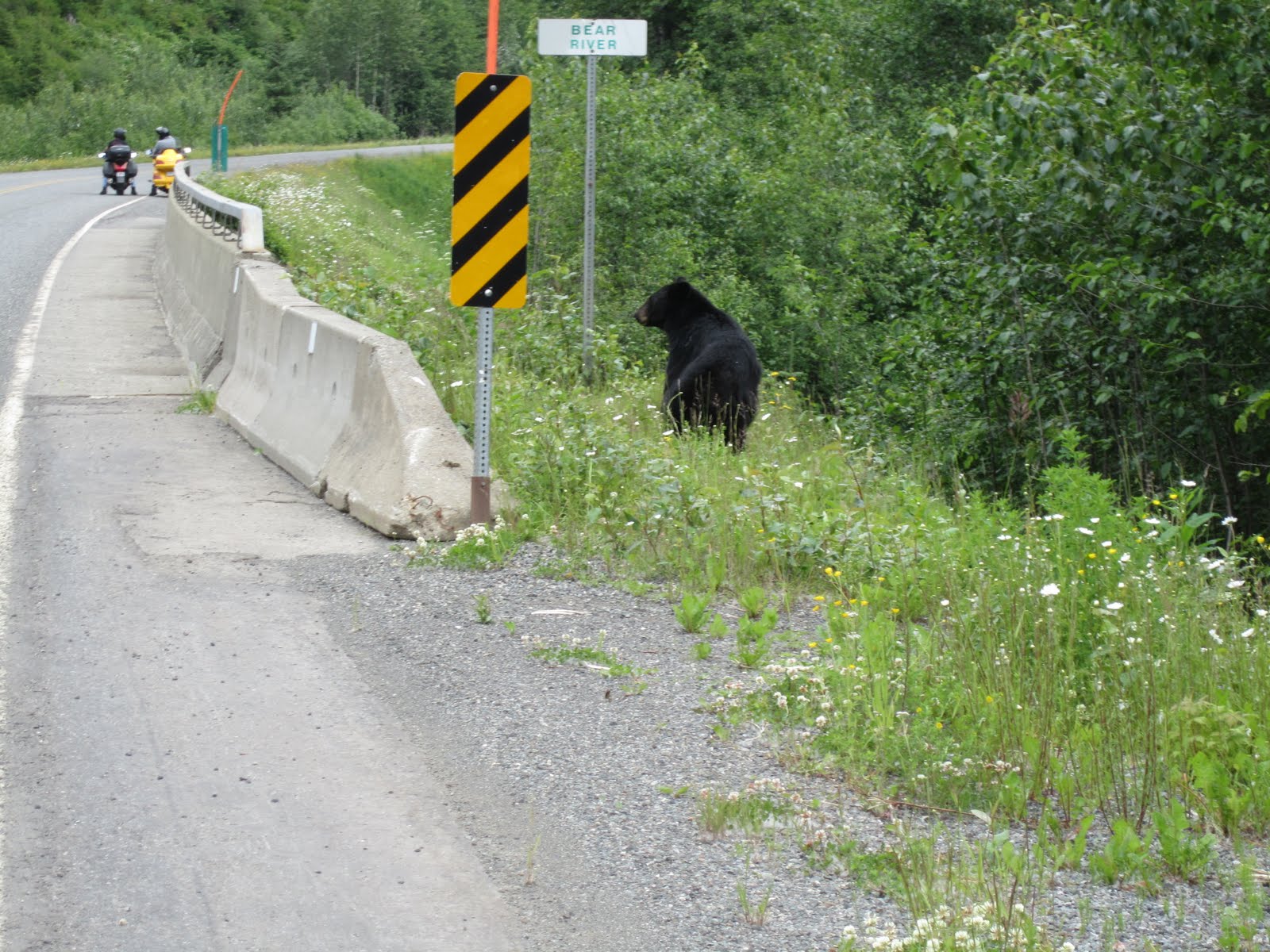
After getting back on 37a, we were crossing "Bear River" and on the right over the rail was a black bear munching on some yummy leaves.  I had to turn around because I'm not that quick on the draw with the camera.  He hung around long enough for a couple pictures, but eventually got spooked and went back into the trees.

Our turn-around point was Bear Glacier, that we saw coming in, but we found one more side road before making it to the glacier.  This was another gravel road which looked well traveled.  At one point I stopped and we talked about how we should be careful because it's probably a haul road.  Last thing we need is to be a bug splat on a speedy logging truck.

We ended up riding till we found this bridge that had two raised wooden tracks in the middle.  Naturally we straddled the planks and parked the bikes in the middle of the bridge for pictures.  After pictures, it was unanimous that we've seen enough of this road and it was time to turn around.


When we got to the glacier, we ran into Glenn, a rider who lives in Fairbanks and was on his way to the Florida Keys.  We had seen him earlier when he pulled over and asked us how far the next fuel south was.  He forgot to fill up before he left Stewart and realized he needs to go back (10 miles) and fill up.  He actually helped us out a lot as he filled us in on the roads we will be traveling.  It was the details like how far exactly is that road we're planning on riding unpaved that helped out a lot.

The main 'todo' for today was to ride up the 20 mile unpaved road from Hyder, into Canada, and check out another glacier.  We got back at a little after 1pm though and it was time for lunch. Paul and I scouted out the fish bus yesterday and wanted to show Steve before he decided to go eat at the pub.  We pulled up and weren't sure at first if it was even open.  A woman's voice piped up from inside the bus, "How you guys doing?"   Great, they're at least open right?  So all together we ordered a couple bowls of chowder, Halibut fish and chips, and I ordered the fresh Dungeness crab the owner was recommending as the most fresh of the meat.

I didn't get any pictures of the food, but you might see some in Steve's gallery.  The food was great, and the crab was a lot of work to eat.  Very fresh for sure.

We continued up the dirt road (all the roads in Hyder are dirt) for our 25 mile trip to the summit of the Salmon Glacier viewpoint.  The wing with the car tire did great on the dirt.  The whole way up there were waterfalls on the side of the road that soon enough you just stop looking at them.

In the thick gravel it feels more like a boat and I wonder if I'm really in as much control as I really think.  The glacier itself was pretty nice.  Nothing I can type here will say it better than the pictures, which hardly do it justice, so why bother right?  On with the riding ...

Coming down the mountain 25-30 was a good speed.  When it flattened out, 40 felt pretty good except for when I hit ruts.  It felt very abusive on the suspension of a 900 pound bike to be hitting ruts like that, but I was having an incredible time.  I was pretty sure I figured out what the next bike would be.

Oh wow, ... I'm writing this at the campground in the saloon where we get internet and Steve just got up to sing Kareoke, Ring of Fire, Johnny Cash.  He's the first person besides the DJ to sing, so he just broke the ice.. I'll post pictures.

So here we are at the Sealaska Inn where you meet exactly the type of folk who would have to be that much  different to be able to spend their entire summers or year round here in Hyder Alaska.  One example is an older gentleman here named Jimmy Drum, aka "Watermelon Jim".

Jim is a short older man with a southern accent in what I would guess is his late 60s.  Jimmy has spent his summers here for the last 25 years.  His sister is up visiting from Portland right now with him.  As I was talking to them his sister prompts him proudly to give me his card.  Reluctantly he hands he his card, loudly titled "Alaska Watermelon Man", in green and red text with three bitten watermelons above it.  His title is "Originator & Creator of Alaska's First Watermelon Festival".

Jim is a semi-retired truck driver that lives in Tennessee, and each year he brings up a truck load of watermelons to Hyder Alaska.  He doesn't sell them, he gives them away.   The way he explained it was "do you know what a hobby is?" ... I questioned "something you spend lots of money ..."  "Exactly! while having fun.".  Ok, now that is one hobby that is truly his own.  He could be the subject of his own post here, but back to the trip.

We'll be leaving tomorrow with much more dirty bikes as we arrived with and it's going to be back to a couple long days of riding till we reach the "interior" of Alaska, as Glenn the rider we met earlier referred to it as.

It's 10 pm and there's still direct sunlight on the mountains outside.  Keep checking the Picasa gallery for the latest pictures.  I really enjoy seeing the comments, but sorry if I don't reply right away.  Keeping this thing up to date is using a lot of internet and battery time as it is.  Hopefully it's as fun to read as it is to write.  Here's a picture I just took from outside the Inn.

Thursday, June 17, 2010

We're in Hyder Alaska (Day 4)

We made it to Hyder Alaska today after another long day of riding.  As we rode north from Lake McLeese, it was like someone grabbed the edges of B.C. and stretched it a little.  It was still pretty green, just not as mountainous.  We headed east on Hwy 16 when we reached Prince George.

There really wasn't much on this stretch of road to side track us, so we rode from about 8am to 1pm where we stopped for lunch at Happy Jack's Pub in Houston B.C.  Just before we got there, the road got pretty bad as there were construction zones out there making repairs.  There's actually a lot of road work always going on it seems here in Canada.  I think it's safe to say that every hour or two of driving through B.C., we pass through an area that breaks down to one way traffic with slow/stop controllers guiding drivers through.

From Houston, Highway 37 ... The Stewart Cassier Highway, ... the road so many riders say you can not miss, was 2 hours away.  We rode on.

Soon after turning onto Hwy 37, it was obvious fuel was going to be an issue.  Although Stewart is more of a side trip 40 miles off the same route, at least two of us weren't going to make it without a fill up there.  Stewart borders a far southern town of Alaska named Hyder.  This was actually a town highlighted in a book I read as a place to see bears.

Paul ended up camping out by some lake on the way, but Steve and I pushed on for Hyder.  We will all meet sometime tomorrow since we're going to take it easy after so many long days of riding.

37a into Stewart ended up being THE most scenic road I've ridden a motorcycle on.  The condition of the road is perfect, and there are many twists and turns, but I couldn't get into the throttle for more than a minute before being distracted by the snowcapped mountains, waterfalls, rivers, glaciers, and ... bears!

One bear anyway.  Steve rode by him pretty fast and kept going on.  I made a quick u-turn to get some pictures.

Tomorrow we'll take it easy exploring the area.  We have internet here, but no mobile service.  It's 10:30 and looks like it's finally going to get dark within an hour or so.

28042

Wednesday, June 16, 2010

McLeese Lake, B.C. (Day 3)

A little over 400 miles today and we ended up at McLeese Lake as recommended by a local.  We took it easy and left around 9am and were at the border within an hour.

The crossing didn't take too long.  They asked some basic questions like where I was heading, how long I was going to be in Canada, if there was anyone I was visiting, how much cash I had on me, and if I was a concealed weapon permit holder .... wait what?  She didn't ask that last one to Paul or Steve.

After some pictures at the "Welcome to Canada" sign, there were lots of official signs, including a "move over, it's the law" sign!  The difference I noticed here though was that people were driving a lot faster.

As we keep going North, it just gets more scenic.  Along CA 1 there are waterfalls practically dumping on the highway.  I didn't get a picture because I thought surely that was the last highway side waterfall in this section of road.

We found a hidden road over a railroad track just past this little town of Yale.  There were gravel patches here and there and it ended up along side of the railroad on the left, and then on the right was a very wide fast flowing river below some very large cliffs.  I think I counted three or four separate waterfalls.

We met another motorcycle rider who recommended we ride Hwy 8. He was a pretty fast rider, but we ended up passing him and the mountie who pulled him over.  It was about a 45 minute ride one way to Little Nicola.  Nice twisties, but we just turned around to get back on our route. Overall a good recommendation.

Had lunch at a pub in 100 Mile House.  There wasn't much around and felt like a mix between a country bar, reno, and a retirement home.  It took about an hour to cook our food, but at that point, we were in no hurry.  It was good to be off of the bikes for a bit. Pretty decent food though!

When we got to McLeese Lake, we were greeted by other riders.  A couple of them owned Harleys, but purchased Dual Sports just for this trip.  They were on their way back from Alaska, which was nice because we got the scoop on key road conditions.